How does the global positioning system operate?
The Global Positioning System (GPS) operates using a network of satellites, ground control stations, and GPS receivers to determine an object’s location anywhere on Earth. Here’s an overview of how GPS works:
1. Satellites
- Constellation of Satellites: GPS relies on a constellation of at least 24 satellites orbiting Earth at an altitude of about 20,200 km (12,550 miles). These satellites are positioned so that at any given time, a GPS receiver on the ground can “see” at least four of them.
- Orbit and Signals: Each satellite orbits the Earth twice a day, transmitting radio signals that include the satellite’s position and the precise time the signal was sent.
2. Triangulation (or Trilateration)
- Distance Measurement: A GPS receiver determines its position by measuring the time it takes for the signals from the satellites to reach it. Since the signals travel at the speed of light, the receiver calculates the distance to each satellite based on how long it took the signal to arrive.
- Position Calculation: To determine the receiver’s precise location, it needs to measure the distance to at least four satellites. The process of determining location through these distance measurements is called trilateration.
3. Atomic Clocks
- Time Accuracy: GPS relies on extremely precise atomic clocks on the satellites. This ensures that the time signals sent by each satellite are accurate, allowing the receiver to precisely calculate the time it took for the signals to travel.
4. Ground Control Stations
- Monitoring: A network of ground stations around the world monitors the GPS satellites. These stations track the satellites’ positions, update their orbital data, and correct any errors in their clocks.
5. Corrections and Adjustments
- Signal Corrections: Atmospheric effects, such as ionospheric and tropospheric delays, can cause signal distortion. Ground control stations constantly update the satellite data to correct for these errors.
- Relativity: GPS also accounts for the effects of relativity. Since the satellites are moving very fast and are farther from Earth’s gravity, their clocks tick slightly faster than clocks on Earth, which is accounted for in the calculations.
6. Receiver’s Output
- Once the GPS receiver has calculated its distance from multiple satellites and applied any necessary corrections, it can determine its position in terms of latitude, longitude, and altitude. This position is then displayed to the user, often along with additional information like speed and direction.
Summary of Process:
- Satellites send time-stamped signals.
- Receiver calculates the time delay of signals to determine distance from each satellite.
- Using trilateration, the receiver computes its position.
- Ground control stations help maintain satellite accuracy.
By continuously receiving signals from multiple satellites, GPS provides location, speed, and time data in real-time.
To delve deeper into the operation of the Global Positioning System (GPS), we can explore the finer aspects of the system, including the key components, error sources, and applications. Here’s more on how GPS works:
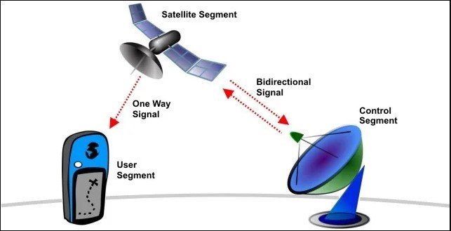
Key Components of the GPS System
GPS relies on three primary segments:
1. Space Segment (Satellites)
- The satellites are positioned in medium Earth orbit (MEO) and follow a specific orbit pattern to ensure that at least four satellites are visible from any point on Earth at any given time.
- Each satellite is equipped with:
- Atomic Clocks: These are highly precise clocks that allow the satellite to timestamp the signals it sends to Earth.
- Broadcast Signal: The signal contains important data:
- Satellite position (ephemeris): This gives the satellite’s exact location at the time the signal was transmitted.
- Almanac data: This provides general information about the status and orbit of all GPS satellites, which helps receivers locate other satellites.
- Time: Accurate time is essential for calculating distances.
- There are currently about 31 operational satellites in the GPS system (as of recent counts), providing redundancy and better global coverage.
2. Control Segment (Ground Stations)
- Ground Control Stations are scattered around the world, including the master control station located in Colorado, USA. These stations have three primary functions:
- Tracking Satellites: They monitor the exact position and health of the GPS satellites.
- Updating Satellites: They send corrected data, such as position adjustments and time corrections, to the satellites.
- Synchronizing Clocks: They keep the atomic clocks on the satellites synchronized with Earth time.
- The Master Control Station processes data from the ground stations and sends commands to the satellites.
3. User Segment (GPS Receivers)
- GPS Receivers are the devices used by people or systems to determine their location. Examples include smartphones, in-car navigation systems, fitness trackers, and professional surveying tools.
- The receiver’s job is to:
- Pick up signals from multiple satellites.
- Use the time and position data from these signals to calculate its location through trilateration.
- Display the location information in terms of latitude, longitude, and altitude.
Trilateration in Detail
Trilateration is the core principle of how a GPS receiver determines its location:
- Distance Calculation: The receiver calculates the distance to each satellite by multiplying the travel time of the satellite’s signal by the speed of light (since the signal is a form of electromagnetic radiation).
- 3D Trilateration:
- With signals from three satellites, the receiver can determine its 2D position (latitude and longitude). However, this creates two possible solutions, one in space and one on Earth (the latter being the realistic one).
- A signal from a fourth satellite provides the additional data needed to calculate altitude and correct for any clock errors within the receiver.
- This process is carried out continuously to provide real-time positioning.
Sources of Errors in GPS
While GPS is incredibly accurate, certain factors can introduce errors into the calculated position:
- Atmospheric Delays:
- Ionosphere: The signal can be delayed as it passes through the ionosphere (a layer of the Earth’s atmosphere filled with charged particles). The higher the satellite’s elevation above the horizon, the shorter the path through the atmosphere, reducing this delay.
- Troposphere: The troposphere, the lower atmosphere, can also slow down the signals due to variations in humidity, temperature, and pressure.
- Multipath Effects:
- Signal Reflections: GPS signals can bounce off buildings, mountains, or other large objects before reaching the receiver, leading to inaccuracies in distance measurements.
- Satellite Geometry:
- The Geometric Dilution of Precision (GDOP) measures the strength of the satellite arrangement. If the satellites are close together in the sky, the geometric configuration can lead to poor accuracy. The more spread out the satellites, the better the accuracy.
- Clock Errors:
- The atomic clocks on the satellites are very precise, but they can drift slightly. The ground stations constantly monitor and adjust for these clock errors.
- Receiver Noise:
- The quality of the GPS receiver also influences accuracy. Cheaper, less sensitive receivers may have more noise, leading to less accurate positioning.
- Intentional Degradation:
- Selective Availability (SA) was a deliberate degradation of the signal that the U.S. government could apply to reduce civilian accuracy. SA was turned off in 2000, but the capability to re-enable it remains in place.
Error Correction Methods
Several techniques have been developed to minimize GPS errors and improve accuracy:
1. Differential GPS (DGPS)
- DGPS involves using a network of ground-based reference stations that broadcast correction signals to nearby GPS receivers. These reference stations are in known locations and can detect GPS signal errors, allowing them to send corrections to the receivers.
2. Wide Area Augmentation System (WAAS)
- WAAS is a system used in the United States that improves the accuracy, integrity, and availability of GPS signals. Ground stations monitor GPS satellites, and correction messages are sent via geostationary satellites to GPS receivers capable of using WAAS.
3. Real-Time Kinematic (RTK)
- RTK is used in precision applications like surveying. It involves using a base station with a known location and a rover (mobile receiver). The base station broadcasts real-time correction data to the rover, allowing for centimeter-level accuracy.
Advanced Applications of GPS
GPS is used in a wide variety of industries and applications beyond navigation:
- Aviation: For flight navigation, landing assistance, and flight tracking.
- Maritime: Used for ship navigation and fishing industries.
- Surveying: High-precision GPS tools are used in construction, mapping, and geology.
- Timing and Synchronization: The precise timing provided by GPS is used to synchronize financial networks, power grids, and communication systems.
- Agriculture: GPS is used for precision farming, helping farmers to optimize planting, fertilizing, and harvesting.
- Emergency Services: GPS allows for quick location tracking for emergency responders and search and rescue operations.
Future of GPS
- Modernization: The GPS system is being continually upgraded. New satellites are equipped with advanced features such as stronger signals, improved clock accuracy, and more channels for civilian and military use.
- Integration with Other Systems: GPS is often combined with other Global Navigation Satellite Systems (GNSS) like Russia’s GLONASS, Europe’s Galileo, and China’s BeiDou to provide enhanced accuracy and reliability.
In summary, GPS is a sophisticated, global system that allows for precise positioning and timing through the use of a constellation of satellites, ground control stations, and GPS receivers. Despite certain limitations, advances in error correction and integration with other systems continue to improve its capabilities.